Introduction
In this module we will be addressing two main subjects, which are sadly lacking in most pleasure yachtsman’s experience – Pilotage and the International Rules for Prevention of Collisions at Sea (IRPCS). In coastal situations, a lack of knowledge of one or both of the above is the cause of most groundings and collisions.
We will also deal with Passage Planning and Pollution.
First let us define the term, to distinguish pilotage from the related subject of navigation.
You are piloting if you can see your
next mark, and you know exactly where you are.
You are navigating if
you can’t and don’t.
Most folk could find their way across an ocean without crashing. There’s
nothing to hit!
Put them near the land and it’s a different story.
Here are a few simple rules that I use when I have to pilot into or out of a new (to me) area. They are not in order and you don’t always use all of them.
When running practical courses, my students always amaze me, by trying to pilot into a harbour using the same chart that we have just crossed the English Channel with!
Generally speaking, if you sail into a Magenta box then it’s time to change the chart you are using. These boxes are there to tell you that there is a better scale chart for the area.
See Training chart 2: Dartmouth Harbour.
There’s a box around the harbour, with the chart number in the bottom right and top left corners. I am afraid that you do not have that chart, but there is a drawing with a similar scale on page 30 of the Practice Navigation Tables (PNT). You can see that there is far more detailed information about lights, buoys, pontoons, depths, ferries etc.
Charts are expensive, but life is so much easier, not to mention safer with good chart coverage.
Some yachtsman’s charts have harbour and "tricky spots" insets around the margins. This can save a few dollars. They are often not as detailed as the Admiralty equivalent.
Before making a passage, the skipper should be as informed as possible about any of the ports that he may have to visit. There is port information in the Almanacs, e.g. Page 31 PNT for Dartmouth. Local knowledge is usually helpful, so call the Harbourmaster. His number is the Almanac. Ask him if there are any byelaws that you need to be aware of, or if there is a regatta going on during the time you want to visit. With no exceptions, I can say that I have only had good responses from Harbour authorities. Most post out a copy of the byelaws. After all it is in their interest for you to get it right!
You can also get information from the various Yachtsmen’s pilot books. There is an example of this for Falmouth on page 12 PNT, from the "Shell Pilot".
From module two, you will remember how to work out the height of tide. If we have a height of tide of 6 metres, we are not too bothered about the drying 0.6 metre sand bar in the entrance to the River Yealm.
Knowing this means that we do not need to get involved in finding transit marks and running around buoys. Just stay in the middle! (In good weather).
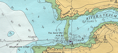
Remember though, that the tide height changes appreciably every ten minutes in the third and fourth hour, so you need to keep checking the height on the tidal curve. If you have a time consuming pilotage problem, you cannot afford to forget the tide. After all, in some situations, the tide might drop by as much as one metre in only half an hour!
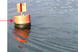 Tidal
stream is also important. You can get this from tidal diamonds and stream
atlases, but in a pilotage situation I tend to look at the tide around
beacons, buoys moored boats etc. At this buoy, the tide is running from left
to right.
Tidal
stream is also important. You can get this from tidal diamonds and stream
atlases, but in a pilotage situation I tend to look at the tide around
beacons, buoys moored boats etc. At this buoy, the tide is running from left
to right.
Often in rivers, the tide may well be eddying and be completely contrary to the tabulated direction.
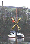
Transits and clearing bearings
These are crucial tools in pilotage.
Is shown on the Yealm entrance chartlet in the previous section. There are two black and white beacons on the hillside, just north of Cellar Bay.
You can see that the Easterly beacon is higher than the West one from the contour lines. (The back one is higher from seaward than the front one) When they come into line from seaward, (one above the other) you can run towards them. This track will clear the Mouthstone ledge. These are charted transit Beacons. Sometimes you will use transit lights and sometimes, for example, two headlands that line up, to keep you safe.
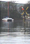 |
 |
 |
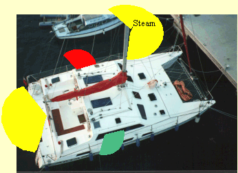
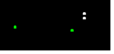
| Go Right... | Straight On... | Go Left... |
...to keep the beacon (cross top mark) in transit with the
catamaran mast (red).
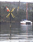
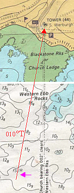
| Clearing bearings
Clearing bearings are a little different. They are used when no transit is available. For these, we use a hand bearing compass. You can see that if we have a bearing of the Tower at 002° T we will clear the Western Ebb rocks. Using a hand bearing compass you can see that if we have a bearing of the Tower at 002° T we will clear the Western Ebb rocks. Moving west would make the bearing increase (010 T). This gives us a bigger clearance. If we were to move east, then the bearing would decrease. When approaching from the east we cannot turn for the Tower until it bears 002° T or more. So we can use a clearing bearing of something we can see, to avoid something that we cannot. Have a look at your chart No1 at the Yealm Entrance. |
 |
|
 |
 |
|
DEPTH CONTOURS
These are also useful in a similar way. If you know the height of tide and the contour line on the chart is relatively straight, then you can either follow it in with the echo sounder or use it rather like a clearing bearing. i.e. stay on one side of a particular depth.
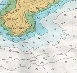 For
example, on a flat day, to save time while rounding Rame Head, we might decide
that we want to keep in as close as possible. We have already assessed the
possibility of overfalls to be minimal. From the chart, there are no
obstructions outside the 10-metre contour line. Knowing that the height of tide
is 3 metres when we are rounding the headland, we therefore simply keep the boat
in no less than 13m to stay out of trouble. On a rougher day or when the wind
and tide are opposed we can see that overfalls extend to the 20m contour. We
could pass the headland making sure that we stay in 20m plus the height of tide.
For
example, on a flat day, to save time while rounding Rame Head, we might decide
that we want to keep in as close as possible. We have already assessed the
possibility of overfalls to be minimal. From the chart, there are no
obstructions outside the 10-metre contour line. Knowing that the height of tide
is 3 metres when we are rounding the headland, we therefore simply keep the boat
in no less than 13m to stay out of trouble. On a rougher day or when the wind
and tide are opposed we can see that overfalls extend to the 20m contour. We
could pass the headland making sure that we stay in 20m plus the height of tide.
Bearing and depth fix. With contours
like these, a Bearing of the chapel and the depth gives a good fix!
Don’t guess: PLAN.
I often see skippers with the chart in the cockpit, trying to pilot. This method does not work! Once you have started your pilotage you must keep your eye on where you’re going. You have no time for messing about with the plotter. (Have you ever tried reading a map while driving in Central London!!!)
A good tip is to draw a map rather than write notes. A picture will show you what and where, much faster than reading through notes. You often don’t have time to write it all down, but a quick sketch will do the job.
 This
"masterpiece"? could get me into Salcombe from the west.
This
"masterpiece"? could get me into Salcombe from the west.
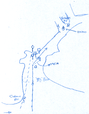
Have a look at the plan on page 27PNT.
- We will first use Cadmus rocks to "Positively Identify" Sandhill Pt beacon. (It will not be easy to see from seaward, at more than a mile off). When Cadmus bears 015° M, the beacon will appear around the rocks on the same bearing.
- Once we have identified it, we keep moving east until our beacon bears 005° M, when it will come into "Transit" with the first of three red and white beacons with square top marks. We run towards it.
- When we have left the green buoy to starboard, we slow down and look for the green beacon on our starboard side. When this beacon bears 095° M, we turn right and stay in the middle of the channel at about 050° M.
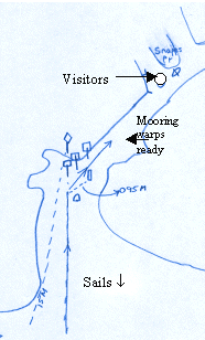
- As we go northeast, we will see a small pier sticking out on the left, with a bay opening out behind it. The visitors’ moorings are just past the pier. If we arrive at the lifeboat, we have gone too far and need to back track.
Using a plan like this, we know where we are at all times.
Note that I have converted bearings to Magnetic. This is important. If you make an easy mistake like subtracting the variation instead of adding it when you are busy with implementing your plan, you will crash. I’ve done it! Convert to magnetic while you are relaxed and have time.
The skipper should do as little as possible when bringing the boat in.
Plan ahead and delegate.
IDENTIFY MARKS POSITIVELY AND BEFORE NEEDED
This is crucial! It is all too easy to see a mark, headland, buoy etc, and assume that it is the one you want. If you get it wrong, you’re in trouble!
There are lots of ways of making sure and I have just used one in the last subject:- using a mark, which you are sure of, to find one that you’re not. We used Cadmus Rks to find the Sandhill Pt beacon.
Sometimes it seems easy. Perhaps the buoy you are looking for is the only one in the harbour, but has it dragged its anchor in the last storm and the information has not filtered through the notices to mariners yet? Check.
If it’s dark then the problem is solved by recognising each buoy or beacons distinct light characteristic – see buoyage and lights, below.
Usually, if you need to use a mark, you will be in a position where you cannot check its identity. Do it before you need it. If we had simply travelled east until we were due south of Salcombe, we would have had nothing to bring into transit to help us find the beacon. (The beacons are very indistinct at that distance.)
There are six criteria, which govern "safe speed" within the IRPCS. (Have a look) These always need to be considered whatever you are doing. A safe speed in terms of pilotage is one that you can cope with. If you are in a tight area or a complicated pilotage, you may need to slow down accordingly. There are times when you need to be at full speed. If you have to enter a harbour against a spring ebb tide, you will be struggling to go forwards even then. If the tide is with you, it can give you too much speed. So much in fact that you may have your engines in astern.
You can set your speed to whatever you like, within defined speed limits, so set it to a speed which is easy to calculate.
E.g. 6 knots, means you will cover 1 mile in ten minutes.
4 knots is 1 mile in 15 minutes.
3 knots is 1 mile in 20 minutes.
All easy numbers. Don’t use 5 knots; it’s too hard when your brain is busy enough.
Bear in mind that the tidal stream does not show on your log – you will need to allow for it when estimating your ground speed.
IF YOU ARE NOT SURE - STOP
I’m told that you cannot stop in a boat. That is true, but you can slow so that you run aground at one knot instead of steaming in at 6 knots!
If you get lost then stop. Turn into the tide and stem it, i.e. go as fast as the tide in the opposite direction. You can then take stock of the situation and if necessary go back to your last mark and start again.
If you cannot see your last mark you are not piloting, you are navigating! You can sometimes stop and grab a free mooring for ten minutes while you re-plan.
PREPARE EARLY
 This
means remembering to take the sails down, get the anchor ready or the mooring
warps and fenders out and rigged, in plenty of time. I have seen a yacht come
alongside with no fenders! After completing a tricky bit of pilotage, the
skipper just forgot all about them.
This
means remembering to take the sails down, get the anchor ready or the mooring
warps and fenders out and rigged, in plenty of time. I have seen a yacht come
alongside with no fenders! After completing a tricky bit of pilotage, the
skipper just forgot all about them.
Be careful here though. Do not try to get sails off at sea if it’s easier to do it in sheltered water, closer in. I do not like to have crew on deck in rough water unless it is necessary. Start your engine early to make sure it is prepared to go. Sometimes they seem very lazy in this respect! Put her in and out of gear, so that you know the prop is not fouled. Then in shelter, all you have to do is turn the boat head to wind and hold station while the crew gets sails down and mooring gear rigged.
A call to the harbour office on VHF (in a busy harbour) at about this point often saves a lot of confusion about which berth you can use.
Brief the crew in the cockpit so that they know what is going to happen and when. This saves a lot of embarrassing shouting closer in. It also avoids waking up other boat crews, who may desperately need sleep if they have to leave at three in the morning to catch the tide!
| CRUCIAL STUFF! |
|
The International Association of Lighthouse Authorities (IALA) has come up with a system of buoys, which are used virtually worldwide. There are two regions, A and B. Region A is the whole of Europe and that is what we will cover. When you go sailing in the States, give me a call first! That’s region B. The system is made up of 5 types of buoy. These buoys can be recognised in a number of ways: - shape, top mark, colour, light character and colour.
CARDINALS
| Just like the four cardinal points of the compass, so there are 4 of these. They tell us how to stay in the safe water around a danger. E.g. always stay north of a North Cardinal bouy. On charts they look something like this. As you can see they all have a black top mark. North and south are easy, but east and west are harder to remember. "West is like a waist" is how I remember it. Underneath each buoy, you will see some letters. They are telling you the painted colours of the buoy. The West Cardinal is YBY, yellow black yellow. The arrows on the top marks point to the black. The two arrows are pointing into the middle, so the black is in between the two yellows. |
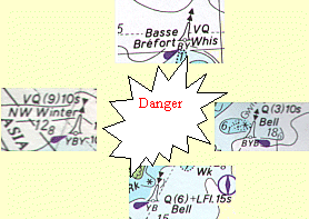 |
All these buoys are also lit. The magenta teardrop tells us this.
On the North Cardinal, you can see VQ. This means a white light and it flashes very quickly, continuously. On the West Cardinal there is VQ(9)10s. This means the light flashes 9 times very quickly in a 10 second period. The South Cardinal, Q(6)+LFL15s, performs 6 quick flashes and then 1 long flash in a 15-second period. The East Cardinal Q(3)10s, means 3 quick flashes in a 10-second period. The "period" is the time between the first flash and the next first flash, including the dark bit!
You can also see that some of the buoys have bells and whistles. These are there so the buoy can be recognised in fog.
CHANNEL MARKERS (LATERAL MARKS)
 Red and green buoys mark channels. They often have top marks and if they do, the red ones have squares on top and the greens have
triangular tops. This matches their shape on the chart.
Red and green buoys mark channels. They often have top marks and if they do, the red ones have squares on top and the greens have
triangular tops. This matches their shape on the chart.
On charts, green buoys look black and red ones take on the colour of the
chart in that area. i.e. they are clear. The same notation is used for lights
and buoy colours as for Cardinal buoys, i.e. R or G is written underneath.
They can flash in any sequence except 2+1.
Leave red buoys to port and green ones to starboard when travelling in the general direction of buoyage or entering a harbour. You can see the general direction of buoyage on your chart by looking for this symbol. It is the rough direction of the flood tide.
DIRECTIONAL LIGHTS
An other way of staying in the channel is to run down a sector light. This is
a very
easy method of piloting into busy harbours. Buoys are hard to see as they are
low
down and can be masked by other boats or waves. Sector lights are
generally
higher and have more powerful lights. Look at chart 2 and Dartmouth harbour.
The Kingswear light (Iso WRG 3s 9m 8M) means :- On for 1.5 secs then off for
1.5 secs
You can see the three sectors out in the sea so you would know which way to
turn
eg Entering, if you were in the red sector, you would turn right to get into
the white one.
9m means 9 metres above MHWS and 9M means light range 9 miles.
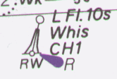
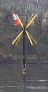
SAFE WATER MARKS (FAIRWAY MARK)
These buoys mark areas of safe water. Usually outside a harbour or tricky area, they mark a good place from which to make an approach.
They can be spherical or pillar shaped, like this one. They always have a red ball on the top, (unless it has been knocked off in bad weather). I like these buoys; they look like ice creams with raspberry sauce dribbling down them, with red and white vertical stripes. The light characteristic can vary as follows, but is always white.
- One long flash in ten seconds,
- Morse Alpha (dit daah)
- Isophase
- Occulting.
Isophase in this context means that the period is split into equal length phases of light and dark, e.g. 5 seconds light and 5 seconds dark in each 10 second period. ‘Iso’ means ‘the same’, like isobar or isosceles. This would be"iso 10sec" on the chart
Occulting means more light than dark, so the light stays on most of
the time, with a short period of darkness.
An occulting light that was on for 3 second then off for three seconds would
be "occ 6 sec"
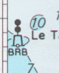
These marks are found on or above dangers. They just mean stay away from me!
They have black and red horizontal stripes and have two black balls on the top. It’s very unusual to see one in the UK, although there are lots in France, where there are lots of isolated rocks!
This one is not a buoy. It is a beacon. Buoys are always shown on a slight incline to show that they are afloat.
This mark is also unlit, but if an Isolated Danger mark is lit and most are, the characteristic will be Group flash two white. That means there will be two flashes close together during the period of e.g. 10 seconds.
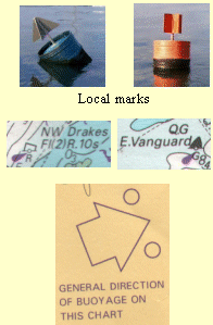
| Are yellow in colour and can be any shape. They
do not have any significant navigational meaning, but if you see a square
one on your chart, it’s best to leave it to port. If it’s a Conical
one, then it is best to leave it to starboard when travelling in the
"general direction of buoyage".
They mark all sorts of things, from sewer outfalls to swimming areas.
They have cross top marks and flash yellow, in any sequence except that
for white lights. |
 |
 |
 Here
is an unlit special mark. This one marks a sewer outfall in my local
creek.
Here
is an unlit special mark. This one marks a sewer outfall in my local
creek.
In the dark it is a real hazard. No there aren’t any roadworks!
Someone has added a reflector!
LIMITATIONS OF BUOYS AS AIDS TO FIXING
Buoys are anchored just like boats. They drag! They also swing about on the chains particularly at LW. So be careful when using them for fixing. There is bound to be some error using buoys. An example could be when using a narrow buoyed channel it is not uncommon to see the buoys aground at very low spring tides!
This subject brings in many skills, from making sure you have the kid’s toys to a battery drill and rivet gun. Somewhere in between comes the weather forecast and charts.
Well before the day you want to sail, in the comfort of home, have a good look at the passage you want to make.
- Have you got enough charts for the passage and pilotage?
- How far is it? How fast do we sail? Will we need to run a night watch or is it an easy day sail?
- Where are the likely dangers, tidal gates, (headlands, drying harbours etc)
- You should also work out the tides so that you know what time you must leave by, and when you have to round that headland to miss the overfalls.
- If you have to divert because someone is sea sick, or the weather turns bad, where can you run to find shelter. You can read all about the route and the harbours from the various pilot books available.
- Do a few simple pilotage plans for the likely harbours, including the ports of refuge.
- Make a plan for provisioning and gear needed, so as to be as prepared as possible.
- Is our crew strong enough and does it have enough experience for the trip. Does it want to go?
- Don’t make a decision without consulting the family! The kids no doubt would like to play on the beach instead, so you may have to sail at night when they’re asleep!
- Does the Coastguard have our CG66 and is it up to date? (See module 6 Logging With The Coastguard).
- Can the boat cope with the passage? This is a big question which you must answer yourself. Some small boats do sail across oceans. If they make it, they are well prepared in every respect. If they don’t, they were not! See stability.
- Customs procedures. If you are going to a destination outside EC waters from an EC country then you will need to collect a customs form from the Customs office or in marina offices normally. These forms change periodically so there is no point in me trying to tell you how to fill it in. Just follow the steps on the form. When you reach the territorial waters of the foreign country, carry out the customs procedure for that country. This can be found in sailing directions, but normally flying the "Q" flag and proceeding to the customs clearance port and area.
On the day:
Have we all had enough sleep to be taking on this passage, or have we been driving half the night to get to the boat and have we just done a full days work before that?! Shouldn’t we get some sleep first?
The weather forecast is not too great? Well, go somewhere else then! You are on holiday remember. Get a five day forecast and then have a think about how you can use the weather to get to where you want to go. Don’t just stick to your plan and find that you go up wind all week.
One of the real skills of skippering is planning, but one just as important is being able to throw the plan out of the window and make a new one, as soon as it becomes obvious that the old plan won’t work!
My family and I plan a Scilly Isles holiday most years. So far we have been to the Channel Islands three times, France once and the Scilly's once! Each holiday, though, has been spent going down or across the wind, not beating! – Well, not every day!
Exercise 23
International Regulations for the Prevention of Collisions at sea.
There is an international agreement between maritime nations to make the IRPCS regulations cover all the oceans.
The "Highway Code" is the set of rules that you must obey when you are driving a car. The IRPCS are very similar, with two major differences.
First as I said, they operate worldwide. Secondly, there is a police force making sure we all keep to the rules on the road. At sea that is impossible. The only way to make sure everyone sticks to the rules is to have very heavy penalties should an accident occur. For example, on the road, if you knocked down a pedestrian you might lose your licence. At sea if you committed a similar offence, you would lose your licence and be sent to prison.
Every master of every vessel must know and apply the rules, from a rowing boat to a Super tanker, from a tidal river to the Atlantic.
There is a very good pamphlet called simply "G2", available from the RYA for about £3 or £4, which will help you with this subject and it is well worth getting because like most information, you only retain it if you use it. Keep the booklet on board for when you need it.
I will attempt to give you the bare essentials of the rules as they apply to the yachtsman.
First a couple of definitions
Underway is a vessel which is not attached to the
bottom or a quay.
Making way is a vessel which is moving through the water.
Stopped a vessel which is underway but stopped
All vessels must keep a look out through 360° at all times. I do not know how anyone can do this, but that is the rule and I think it is the most important one!
How do we know if the vessel we can see is on a collision course?
This is easy. If the other vessel stays on the same compass bearing from you, both vessels are on a collision course. That means if you took a bearing with a hand-bearing compass of the ship in question, it would remain on a constant bearing.
Another method is to stand in one position and line up the ship’s bow with something stationary on your boat (perhaps a stanchion). By watching this "transit" between the stanchion and the ship, we can see if a collision course exists.
If the relative bearing only changes a small amount then keep checking and prepare to take action.
Who gives way and who doesn’t?
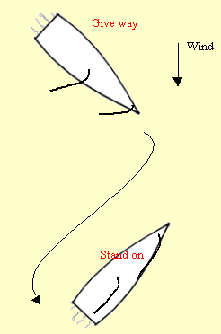
All vessels have a responsibility to avoid collision at all costs, but there is a "give way" vessel and a "stand on" vessel.
Must do three things. She must
- Hold her course
- Maintain her speed
- Act with due regard for good seamanship.
Course and speed are easy, but what about the last bit? This means that she must plan what she will do, should the "give way" vessel fail to change course to avoid the collision. The skipper must decide (from the rules) what action the "give way" vessel should take and if she does not take it early enough, then he must avoid her. But he must do so, such that if the other vessel alters course late he will not make matters worse.
We do not want the classic ‘two men in a doorway’ situation, where both men try to get out of the other’s way, only to find that the other has moved in the same direction and is blocking the way.
Must also do three things. She must
- Alter course Early
- Alter course Positively
- Act with due regard for good seamanship.
She must not leave things so late as to make the stand on vessel suppose that she will not alter course. I take this to mean that if you are the give way vessel, you should alter as soon as you find out that there is a collision course.
She must alter course positively, so that the other vessel can be in no doubt that she has altered course. At night this is done so as to change your vessels light aspect (more about lights later, bear with me).
She must use good seamanship. For example, there is no point altering to miss him if you will then have a collision with me. Look around first!
There is a set of rules that govern power driven vessels on collision course with other powered craft and a set for sailing vessels on collision courses with other sailing vessels.
Vessels under power
There are three rules, which govern who should give way to who when two power driven vessels are on a collision course.
|
1, In a head-on situation, both boats must turn to starboard. Like driving in France or the USA, you keep to the right. |
 |
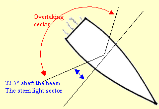
| 2, Over taking vessels must give way. You are
overtaking if you can see any athwart ships bulkhead or at night a stern
light. There is an angle for this. You are overtaking if you are on or
more than 22.5° abaft the beam. This is where the
stern light sector starts. (Again, bear with me; I’m coming to lights)
The overtaking vessel does not become a crossing vessel when she is half
way past. She must keep clear until she is past and clear.
|
|
|
|
|
|
3, Crossing vessels. This one is also easy, but if you mix it up it is catastrophic! Arriving at a roundabout in the UK we give way to vehicles on our right. It is the same at sea. If you have a vessel on a collision course in the sector from ahead to 22.5° abaft the beam, on your Starboard side (right), you must give way. This is the green navigation light sector. |
 |
You can give way by any means, but preferably by altering course to starboard and therefore passing around the stern.
"If to starboard red appear, tis your duty to
keep clear".
Conversely, if you have a vessel on your port side you must
stand on.
| CRUCIAL STUFF! |
When under power:
|
Sailing vessels
There is a different set of rules for two sailing vessels on a collision course and they must never be confused with the rules above. One rule is used for all vessels. "The overtaking vessel keeps clear".
There are three other rules for sailing vessels. They are very different as they use the wind, rather than the relative position of the two boats, to determine who does what. First we need to know a bit about the wind and sailboats.
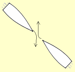
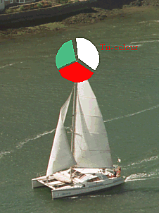
A sailing boat is always on port or starboard "tack". The way to judge this is quite simple:
| If the wind is blowing from the port side to the starboard side, usually heeling the boat to starboard, she is on a port tack. If the wind is coming over the starboard side and heeling the boat to port, she is on a starboard tack. | 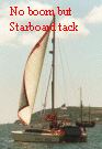 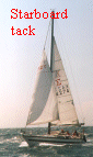 |
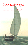
| Sometimes when running down wind the vessel does not heel,
as in this picture. (Cats tend not to heel!) This boat is "goose
winged", with the mainsail on the starboard side and the foresail
on port. She is on a port tack.
The boom or aft sail tells us which tack a boat is on.
|
 |
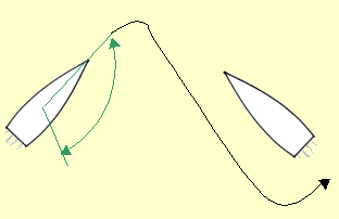
| 1, Vessels on opposite tacks; the vessel on
port tack gives way
If the circumstances of the case admit, she should turn to starboard.
|

|
|
|
|
| 2, Vessels on the same tack; the windward
boat gives way.
The windward boat is the boat that is up wind of the other. The windward boat can keep clear by slowing down, but it is not a clear message to the other skipper. In this case it would be better to turn to starboard.
|
 |
| 3, If you are close hauled on a PORT tack on
a collision course with a boat to windward of you, and the tack of the
other vessel is unclear - give way.
This is a tricky rule to write down! I’ve been teaching it for years, but I still haven’t found a short way of explaining it! This rule has become more important due to the introduction of deck sweeping headsails and large, low footed spinnakers. It has always been used at night of course as we cannot see sails then! If you are the boat going to windward, not only is it hard for you to establish what tack the other boat is on, but also the boat coming downwind might not have seen you, as you are obscured by her sails. |
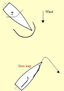 |
There are two possibilities here.
1, The vessel close hauled on port tack (you) might be the give way vessel, if the boat to windward is on starboard tack. (Port and starboard tack rule)
2, The vessel to windward might be the give way vessel, if she is on port tack. (Windward boat rule).
There is a conflict here, so we use the "unclear tack rule".
The boat close hauled on the port tack must alter course earlier than normal, because the boat to windward may alter at the same time creating a "two men in a doorway" fiasco.
Normally when going to windward, trying desperately to claw our way home, the last thing we want to do is to run down wind again! Ground to windward is hard won!
But in a close quarters situation, that is our only choice.
If we tack, the boat to windward may gybe at the same time! There will not be enough time and distance left to avert a collision. Remember when you are gybing and tacking, sails are flogging about and we are not concentrating on the other vessel. We are not expecting her to have altered as well, and bang! By bearing away down wind, we are altering course to starboard and making ourselves a small target and easy to avoid.
I have said that the give way vessel should alter course early. If you have plenty of space, then by all means tack and carry on beating. That is not always possible, I’m afraid.
I was once beating back through the Alderney race in the dark, aboard a 60’ Schooner, on a port tack at the time. It was a bad night, with a rough sea and raining. Suddenly I saw a green light on my port bow. In other words, there was another sailing vessel upwind of us, the very situation I have been talking about. Yes; it happens in the dark too! She was very close, perhaps 200 yards off. I threw the wheel over and tacked. This was a large charter yacht with only my wife and myself aboard. She had four sails to get across and they were big for two people. When I looked up from my task I was horrified to see a 40’ yacht come sliding down my starboard side, so close that I could see the helmsman’s face in the light from his compass light, just a few feet away! He had gybed as I tacked. Our combined speed was about 20 knots and if we had collided, I would not be writing this!
What did I do wrong?
I did not use "good seamanship". I did not think about what the other guy might do. He was on a port tack, so quite rightly went to pass around my stern. At the last moment he crash gybed back onto port tack to miss us.
What should I have done?
Borne away down wind. Next time I will, you can be sure of that and I hope you will remember and do it too!
Another point comes out of this. It would be useful in a big sea if yachtsmen would use high navigation lights, like a "tricolour", rather than silly little pulpit mounted bi-colours, which spend most of their time under water. These only contribute towards the risk of collision, by making yachts virtually invisible in bad weather. In this case, though, we were showing navigation lights and sailing lights at the masthead. I don’t know why our friend did not see us and take action earlier.
OK, enough wittering on! Back to work.
| CRUCIAL STUFF! |
|
It is not quite as simple as I have made out. All the rules above, both power and sail, apply to simple situations in the open sea. There are more.
Within the rules, there is also a priority of vessels list. This overrules some of the above.
 Day signals (cylinders,
balls, hourglass shapes, inverted cones and diamonds) are three-dimensional and
can be seen all around. Take them down when not in use!
Day signals (cylinders,
balls, hourglass shapes, inverted cones and diamonds) are three-dimensional and
can be seen all around. Take them down when not in use!
Sailing boats, when under power with sails up, show a black triangle point down - a motoring cone. The night time lights are displayed where they can best be seen and are also all round lights. Ships show navigation and steaming lights in addition. More later, read on.
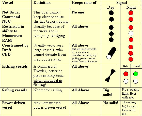
The table above puts a few spanners in the works. For example, a power-driven vessel would normally keep clear of a vessel under sail, BUT, if that power-driven vessel is also CBD, RAM, or fishing the sailboat must keep clear!
There’s more! Is your brain turning off yet? Yes? Go have a brew or a run
around the block.
You’re back?
Narrow Channels
A vessel of less than 20 metres, or a sailing vessel, must not impede the passage of a vessel that can only safely navigate within the channel.
This rule gets us yachtsman into all sorts of bad press. Most of us either don’t know it or ignore it, which is very bad form indeed and will lead to prosecution. A "narrow channel" is not defined within the rules on purpose. The English Channel could be a narrow one to a very large ship in the Dover Strait. A narrow creek could be the same for a yacht among a fleet of dinghies. Nearly all harbours are narrow channels and small boats must keep clear of big ones!
Traffic Separation Schemes.
These are shown in Magenta blocks on chart No 1. They are the motorways of the sea.
| They have ‘hard shoulders’ and ‘central reservations’. No one is allowed to drive
up either of these, but you can cross them. If you want to cross a motorway or
busy road, you tend to do it at right angles to the flow and do it quickly when
no traffic is coming, yes? That’s the traffic scheme rules in a nutshell. You
must also do fairly obvious things like go in the correct direction. Imagine the
havoc caused by some nutter driving down the motorway the wrong way! Anchoring is prohibited and if you join other than at the end of a lane, then join at as shallow an angle as possible. When it is necessary to cross a separation scheme, you should make sure that your heading not your ground track are at ninety degrees to the traffic flow |
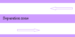 |
Vessels of less than 20 metres and sailing vessels should keep clear of large vessels following the traffic lane.
| CRUCIAL STUFF! |
|
A yacht of less than 12 metres (most yachts) must show:
|
 |
|
There are a couple of alternatives. She can show the sidelights as a combined
lantern (Bi colour) and she can show the stern light and steaming light as a
combined lantern at the mast head.
As Coastal skippers you will get used to the Bi colour's not working. If they are attached to the pulpit they get very wet and pack up. Always have an alternative or move your side lights aft as shown. Yachts Under sail |
|
| A yacht of up to 12
metres in length can show a "tricolour" light at the mast
head. These are high up and therefore very visible and they only have one
bulb, which saves electricity. This is a major concern when we only work
from a twelve volt battery system. Offshore, this is the light to use.
Around a harbour, when there are lots of street lights at about mast head height, which may hide the tricolour, it is best to use the alternative; the deck-mounted side and stern lights. NEVER use the tricolour with any other light. Yachts of under 7 metres need only carry a white all round light at any time. Very occasionally you might see a sailing vessel showing all round red over all round green lights as well as her navigation lights, but she must not a tricolour at the same time. These are generally larger sailing ships.
|
 |
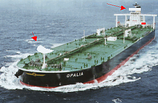
| Vessels over 50 metres must show two
steaming lights when making way. They are on the fore and aft line,
as with a power-driven yacht. The aft light must be higher than the forward
light.
This vessel is a VLCC (Very Large Crude Carrier) and would show constrained by draft signals in narrow channels. They can be up to a quarter of a mile long and carry about 300,000 tons. Their stopping distance is measured in miles not yards! |
  |
|
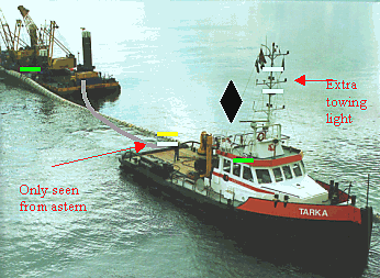
During the day, a
towing vessel must show a diamond shape where it can best be seen, if the
length of the tow exceeds 200 metres.
At night, she must show an extra white towing light in a vertical line above or below the steaming light and through the same arc. If the length of tow exceeds 200 metres, she must show another in the same way. Towing vessels must always show a yellow light above their stern light and through the same arc. The towed vessel shows sidelights and stern light only. If the object being towed is semi submerged, eg a pontoon or the like. An all round white light light must be displayed fore and aft. If this object has a wide beam (over 25 meters) Two additional white lights must be displayed at the extremities of breadth.
|
  |
|
Anchored Vessels
All anchored vessels must show a ball shape where it can best be seen, during the day. They must show a white all around light at night. Often on small yachts this light is a paraffin hurricane lamp, again to save the batteries. If the vessel is 50 metres in length or over, she must show a white light, high in the bow and a white light low in the stern. We also need to ring a bell in restricted Visibility. |
 |
| Vessels aground must show three black balls in a vertical line. I remember this one as a total balls up! |
Dredgers. Can show two diamonds (one above the other) on the side they
would like you to pass.
And two balls on the other side, which tells you to stay clear. Think about
other 2 ball signals for this one and its obvious. eg Isolated danger mark or
Vessel NUC
Small Vessels
are still required to show lights as follows. Vessels under 7 meters
must show an all around white light and if practicable also have side lights. In
our yacht tenders a torch is all that is necessary.
However in a faster small craft (over 7 knots) You must carry an all round
white and side lights.
FLAGS
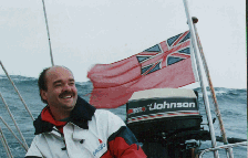 All
vessels must show the flag of their country. It is a good idea to take your
"ensign" down at sunset, as no one can see it in the dark! Hoist it
again at dawn, then it will last twice as long. This is a British "Red
Ensign".
All
vessels must show the flag of their country. It is a good idea to take your
"ensign" down at sunset, as no one can see it in the dark! Hoist it
again at dawn, then it will last twice as long. This is a British "Red
Ensign".
There are other coloured UK flags for the Navy and various clubs; blue and
white ensigns. This is quite confusing for other countries’ officials. UK
vessels do not fly the Union Jack. This is the Queen’s flag, so I’m told.
Only "Her Majesty’s Ships" can use it and even then, only when
anchored or alongside. The country flag or ensign is usually flown aft and
traditionally it was flown from the Gaff .
Other flags, such as "courtesy flags" (used when visiting another country) and signal flags, are flown from the starboard cross tree . There are few signal flags in use today, but a Yellow flag (flag Quebec) is still used when wanting to clear customs to gain entry into a foreign country. You will still see Romeo and Yankee being flown together. It means : Pass slowly and don't make wash.
 Flag "A" is also worth a mention. This one means "I have a
diver down, keep clear". Strictly speaking, you should not see a flag but a
rigid replica of one (as shown on the barge). Most smaller, amateur dive boats do not use a rigid shape and
therefore if you are approaching from straight up or down wind, you cannot see
the flag. My advise here is this. If you see a RIB (Rigid inflatable boat)
hanging about in one area, assume that he has divers and keep clear. If you get
too close they may sound "dit daah ", which is Morse Alpha and means
the same thing.
Flag "A" is also worth a mention. This one means "I have a
diver down, keep clear". Strictly speaking, you should not see a flag but a
rigid replica of one (as shown on the barge). Most smaller, amateur dive boats do not use a rigid shape and
therefore if you are approaching from straight up or down wind, you cannot see
the flag. My advise here is this. If you see a RIB (Rigid inflatable boat)
hanging about in one area, assume that he has divers and keep clear. If you get
too close they may sound "dit daah ", which is Morse Alpha and means
the same thing.
The IRPCS specify six criteria to help the skipper determine a safe speed: -
- The manoeuvrability of the vessel.
- The traffic density.
- The state of the wind, sea and current.
- The presence of background shore lights at night. A bit obscure perhaps, but the first time a ship sneaks along in front of a town, then jumps out in front of you, you’ll know what I mean.
- The visibility, with particular regard to your vessel’s stopping distance.
- Draught in relation to available depth.
Because these are in the rules, you MUST observe a safe speed.
| CRUCIAL STUFF! |
|
Well that’s the collision regulations. Remember that if you keep a look out, you are unlikely to ever have a crash! And the rules say that you must keep a lookout. You know how to work out if you are on a collision course. You know how to work out whether you are the give way or the stand on vessel and what to do in either situation.
You know the rules under power and under sail, but it will probably take a while to understand the wind. We also know that there are some vessels that have priority over others because of their special condition and that these boats carry signals and lights to let us know. We know what lights, shapes or sound signals we should use and when. We are not going to get in the way either in separation schemes or narrow channels.
Keep your eyes open!
Pollution doesn’t fall under the International Rules for Prevention of Collisions at Sea. Nevertheless, it’s in everyone’s interest to look after our environment, whenever and however we can.
Pollution has become a major problem on the sea. Since the year dot, everything from sewage to nuclear waste has been dumped at sea. This still goes on today. For example, at the time of writing, most coastal towns and villages pipe their sewage straight out into the sea. It does get "stage one" treatment first. This sounds very grand, but in fact this just means that the big lumps get broken up. Sorry to be a bit base, but that’s the truth of it.
What can the yachtsman do about it? Complain! Write to the "National Rivers Authority". They are responsible for trying to do something about this problem and if you see that your harbour and coastline is fouled with sewage, tell them.
It is not all gloom and doom. The National Rivers Authority are going around our coast forcing towns and villages through their councils to be put onto mains sewage, but this is a long job and very costly.
In marinas, locked harbours or weak tidal harbours do not use the yacht’s toilet. Go ashore to the facilities – some processing is better than none! If you fit a holding tank to your boat, you can go out over three miles before discharging, but a much better solution, if there is one in your area is to use the sewage pump-out facility. We have one at Fowey in Cornwall, but it is the only one I have ever seen.
There is also the problem of what to do with our rubbish? Suffice to say that you take it home and put in a dustbin. Do not throw it over the side!
On long voyages, it might be a good idea to invest in a rubbish compactor.
Oil spill and antifouling affect wildlife around our coasts very badly.
Put your waste oil in the proper place, not in the sea. When filling tanks with diesel, be careful and use the dispersant which is provided at the fuel depot if you do spill some.
Get advice as to the least harmful antifouling recommended for your cruising area.
Read the "Tide Lines" booklet in your course pack.
Exercise 25
That’s the end of module 5.
You now know how to get safely into your chosen destination, without speeding, crashing or upsetting the neighbours.
You can plan your next passage in comfort and well in advance, but on the day the plan may well have to change.
You can recognise other vessels and what they’re up to, by night and by day.
You know when to give way and when to stand on.
You know what all those cans and sticks in the mud really mean and how to avoid the dangers they mark.
And you know that we are all responsible for looking after the coast and sea, which give us such a lot of pleasure.